|
VIRGINIA POINT – CAMPBELL BAYOU TRIP
Saturday, January 30, 2010, 9:00 a.m.
|
| |
| Trip Description: |
| |
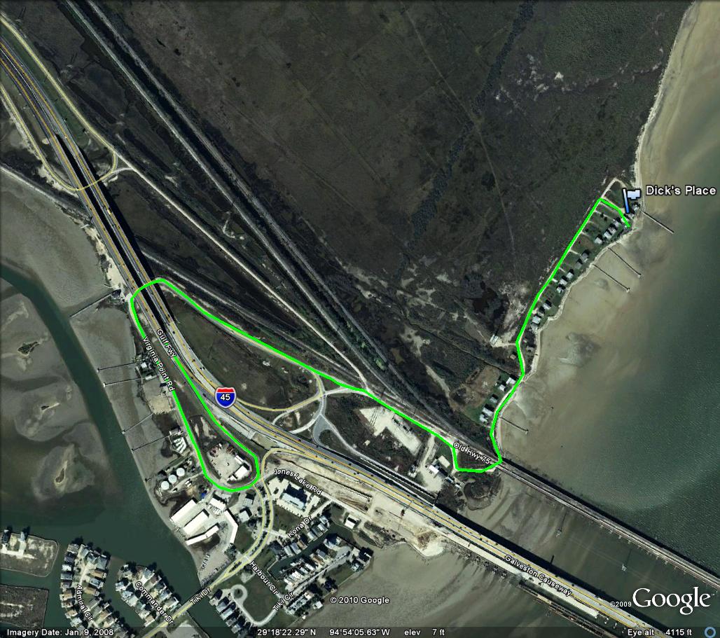
DAY TRIP. Launch Point is Dick McGonigle and Lisa Bell’s 428 Virginia Point Road fishing camp on Virginia Point at 9:00 a.m. Once under and through the first arch of the railroad bridge, continue though the open gate of the Scenic Galveston wildlife refuge to the end of Virginia Point Road turning right on a paved pink driveway bounded by a red and a green ICC buoy. Look for a LARGE red and white umbrella.
Massive oyster shell reefs on Virginia Point that sank 3 of pirate Jean LaFitte’s ships long ago, and which played a strategic role at Fort Hebert in the Battle of Galveston in the Civil War, and which are the subject of Texas A & M professor emeritus Sammy Ray’s current oyster research, form the launch point at the beginning of this trip.
Facing lower Galveston Bay looking across to Galveston Island the launch is situated on a shoreline of fertile pier pilings with shell pads, reefs and guts, with scattered firm mud and sand bottom. Panning 1/3 mile to the right is the 2 ½ mile 1935 Causeway to Galveston (now the railroad bridge to Galveston) under which the tides passes to feed upper West Galveston Bay. The habitat and fishing structure of this bridge of many dozens of fishable arches, along with the new causeway next to it, is unique on the gulf coast. And the night fishing is extraordinary on the new causeway with hundreds of Department of Homeland Security lights on the columns.
Paddling north from launch 2.2 miles down the shore to Campbell Bayou, one can fish the reefs outside the entrance to Swan Lake where one of our speaker-guides Steve Coffee frequents. Or fishing in the shallower protected Swan Lake may look good.
On the way to and from Campbell Bayou are many reef points, islands and guts which themselves are destinations to guides and locals. Guide Bubba Ray plies Double Reef daily in March and April; Danger Point is the subject of trout tales and the entire stretch has an enormous history of flounder gigging. The dark mud crescent immediately left out of port has been good for redfish and flounder.
Weather will be cool 56-67 degrees, but water will be colder. It should be sunny with 11 knot winds NNE, so enjoy the paddle back from Campbell.
Skill Level: Beginner
Note Paddling distance is approximately 1/2 to 2.5 miles each way depending on your choices.
|
| |
| Leader: |
| |
Dick McGonigle, aka DICKMC, click here to email, 713-498-1747
Alternate - Adrian Ramos, click here to email, 832-526-5677
|
| |
| Date/Time: |
| |
We will meet at 428 Virginia Point Roadat 9:00 a.m., Saturday, January 30, 2010.
GPS coordinates are N29 18.500’, W94 53.791’
Donuts/Kolaches will be served at 8:30 a.m. BYOC (Bring your own coffee). There may be a bar-b-q after.
Please sign in on Trip – ‘Paddle Out List’ upon arrival and sign out upon return. Communication will be maintained on VHF Radios and will be tuned to Channel 69.
|
| |
| How to Sign Up: |
| |
If you want to go, contact the trip leader (or sign up at a monthly meeting) and provide: name, email address and phone number (preferably cell phone). or Register for a PACK login account and then use the Auto Enroll link above to automatically have your name added to the list below.
|
| |
| How to Get There: |
| |
From Houston: (located just left of and before the Galveston Island Causeway Bridge.)
1. Take I-45 South to Galveston
2. Take exit for Tiki Island, at the stop sign turn right
3. Heading North back toward Santa Fe overpass you will see Fat Boy’s Bait Camp.
4. Turn Right at Fat Boy’s under the freeway, and turn right again paralling I-45.
5. Veer to the left behind Bubba’s Sports Bar as if to drive onto the brick railroad bridge. Just before the bridge follow the gravel path to the right around the dumpster traveling down along side of the bridge and continuing under the first arch of the rail road bridge, and on thru the gate at the beginning of the Scenic Galveston Wetlands Preserve. PLEASE NOTE THE CENTER OF THE ARCH OF THE RAILROAD BRIDGE HAS A RELIABLE HEIGHT OF 100 INCHES – 8 FOOT, 4INCHES !!! WATCH OUT FOR THE HEIGHT OF YOUR KAYAKS ON TOP OF YOUR VEHICLES!
6. Continue down Virginia Point Road until almost the end, turning right down a pink paved driveway bounded by a red and a green ICC buoy. Look for a LARGE red and white umbrella.
|
| |
| MAPS / Photos of Interest: |
| |
|
| |
| What to Pack/Bring: |
| |
See Standard PACK List for items to consider for any PACK outing
Important items:
- VHF Radio for communication and emergency contact
- First Aid Kit
- Lunch, Water, snacks
- Kayak Drift Sock
|
| |
| REQUIRED READING: |
| |
Recommended guidelines for participates:
- Make sure trip leader or an officer has your emergency contact
- Notify the trip leader if you have any potential concerns
- If inexperienced, then buddy up. Make sure the trip leader knows your experience level
- Communicate with the trip leader, if you are unsure of your skill level required
- Member dues are current
- Guests are invited to particpate
- Have performed deep water entries
- Cary a first aid kit
- Have a life jacket
- Have a VHF radio
- Inform the trip leader of your float plan if planning to fish alone or longer then the designated times.
- Sign in and sign out at the launch site. Inform the trip leader if you will be launching in a different place.
Recommended for Trip Leaders:
- Insures proper authorizations
- Secure sites
- Prepare emergency preparedness plan
- Keep abreast of weather conditions that might effect the trip
- Point out any potential area hazards
- Maintain a head count
- Have available a first aid kit
- Have a VHF radio
|
| |
|
Expenses/Fees:
|
| |
None
|
| |
| Fishing Options: |
| |
Other optional fishing venues include North Deer Island and Jones Lake. These other areas mentioned can be seen on the TOP SPOT Fishing Map.
|
| |
| Guest Participants: |
| |
(We prefer for you to create a login account on this website so that you can have your name added to the auto register list below. If you don't have a registered login account on this website we can list your name here; please contact the trip leader to request your name to manually added. If you have a login account then use the enroll feature at the top of this page to become part of the auto enroll list below)
-
-
|
| |