Event Detail

Panther Point- Leader: Frank Canneto
  Event has started, it is no longer possible to enroll.
Start Date/Time: Friday, October 19, 2007 10:00 AM
End Date/Time: Sunday, October 21, 2007 3:00 PM
Recurring Event: One time event
Category:
Club Social
Event Photos:
Event Report:
Description:

Panther Point at Matagorda Island
October 19-21, 2007

 
Trip Description:
 

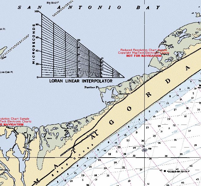
PANTHER POINT is a cape (at 28°13' N, 96°42' W) on the western end of Matagorda Island that extends into San Antonio Bay (Southeast Shoreline) in southwestern Calhoun County. The local terrain consists of tidal marshes with poorly drained sandy loam soils; the water stands twenty inches deep in the marsh. There is little vegetation except for some coastal grasses. The PACK Group will camp at Panther Point on the bay side adjacent to Panther Lake.

 
From Panther Point to the Second Chain of Islands - The south shoreline between the second chain of islands and Panther Point is a legendary spring and summer wade-fishing hotspot.  With areas of dense grass and potholes, it supports a large trout and redfish population.  In a south or southeast wind, this shoreline is crystal clear; its grass can maintain water clarity in some surprisingly adverse wind.  In past trips in the Fall club members have been most successful paddling down this shoreline and entering the lakes and sight casting to redfish.  There are often holes in the channels which seem to hold the majority of the fish. 

  
The deeper tidal lakes are boggy in spots, but yakers who start at Panther Point and paddle northward will find an extensive shell reef that runs for about 3 miles.  Panther reef is about 200 yards off the point.  At normal tides, most of the reef is about 2 feet below the surface.  The west side of the reef drops off to about 6 feet.  To date club members have not focused on the reef however several people have fished towards the reef with DOA shrimp and been successful in landing trout.

 
The stretch of shoreline from Panther Point to the Second Chain of Islands is good for wadefishing, with many channels and depressions.  With its many small creeks, it is similar to Green’s Bayou on the Matagorda Peninsula.
 

Those heading to the First Chain of Islands should also check out the Point of Ayres shoreline.  Redfish will hold on this stretch of shore, which is good for wadefishing.


Leader:
 
Frank Canneto (frank.canneto @williams.com, home: 281-257-2644, office: 713-215-2830, cell: 713-444-0614). 
 
Date/Time:
 
Depart Friday, October 19, 10:00 am (it takes 1 - 1.5 hours to load boat; boat to leave at 10:00 am.) return Sunday, October 21, 2:00-3.00 pm.
 
How to Sign Up:
 

If you want to go, contact the trip leader (or sign up at a monthly meeting) and provide: name, email address and phone number (preferably cell phone).

 
How to Get There:
 
We will be taking a mother boat, The Skimmer, to Panther Point.  The boat is located in Fulton on the bay, approximately 3 hours driving from Sugar Land area as follows (Click here for directions and map)
 
 
Expenses/Fees::
 

We will be using the services of Rockport Birding and Kayak Adventures, Captain Tommy Moore has a 40 foot long vessel called the "Skimmer" which draws only 2 feet of water and can carry up to 45 people.  The costs are $60 per person including the kayak; and we must have a minimum of 10 people sign up.

  
To secure the mother boat we must make a deposit so please acknowledge your intention if you plan on going.  Bring a check payable to PACK in the amount of $60 to the March PACK meeting or send your check via snail mail to:

      PACK
      P.O. Box 75207
      Houston, TX 77234-5207


Accommodations – Primitive Camping:


We will be tent camping on the shell bar.  The area allows you to leave your kayak pulled up near the campsites for easy re-launch.  There are no shelters, water, or restrooms.  All food, water, stoves, etc. must be brought to Panther Point via the mother boat.  The mother boat will deliver us as close as possible to the camping location.  It may be necessary to offload the mother boat as far away as 100 yards to a quarter mile from our ultimate camping destination depending on tide.  However for the past several trips the Skimmer has been able to pull right up to the shell bar where we will camping allowing for direct unloading from the boat to land.  Remember, your personal camping gear will need to be transported via your kayak the final 100 yards plus.  See Packing Considerations for PACK Outings.   Reminder – there will be mosquito’s.

 
Guest Participants:
 
(if you don't have a registered login account on this website we can list your name here; if you have a login account then use the enroll feature at the top of this page to become part of the auto enroll list below) 
 

1.

2.


Owned by sharkyakker On Tuesday, January 9, 2007