|
Description:
|
|
Texas Keys - Snook Trip
June 27-29, 2008
|
| |
| Trip Description: |
| |
PACK’s first trek for the elusive but exciting South Texas Snook will originate from the 59 Diner on SH59 south just south of Beltway 8 (off of Belfort) at 5:00am on Friday June 27, 2008. It will be day 1 of a 3 day adventure. The Snook Hunters will drive 360 miles to Boca Chica State Park and camp on the beach or if allowed on the property adjacent to one of the beach houses in the dunes.
Our route to the Snook Hunter grounds will take us south on SH 59 thru El Campo, thru Victoria where we take US77 South thru Refugio, Kingsville (my birthplace), Harlingen and Brownsville. In Brownsville, we’ll get lost for a little while, get something to eat, ask directions, then travel east on SR 4 for about 23 miles to Boca Chica State Park. We then turn north up the beach to the jetties and camping area. It will take approximately 6-7 or maybe 8 hours to drive depending on breaks and stops. A convoy with cell phone or two way radio communication will be essential.
This will be remote camping – no facilities, no electrical, no water, no shade, no nada.. We will have to bring all of gear with us. See the attached maps for directions on how to get down there.
We launch from the south east corner of south bay we go in thru boca chica beach there is an entrance about 1/2 to 1mile before the jetties and you just follow the road about 1/2 a mile in and you’re there ,you’re in three foot of water in about 10yds. The wind usually drifts you to the old blinds and there is a huge deep hole 6ft.
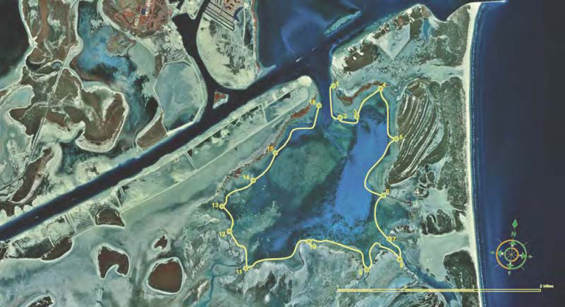
Snook holes - Go to Texas Parks & Wildlife - South Bay Paddling Trail
Marker #4 Go both east and west in that little cove
Marker 7 at a falling tide out in front
Marker 8 high tide up into the mangrove swamp
Marker 9 falling tide out in front
Marker 10 &12 Reds in front on the shell at high tide
|
| |
| Leader: |
| |
Adrian Ramos, click here to email, phone 832-526-5677
|
| |
| Date/Time: |
| |
Friday June 27, 2008 10:00am thru Sunday June 29, 2008 2:00pm
|
| |
| How to Sign Up: |
| |
If you want to go, contact the trip leader (or sign up at a monthly meeting) and provide: name, email address and phone number (preferably cell phone). or Register for a PACK login account and then use the Auto Enroll link above to automatically have your name added to the list below.
|
| |
| How to Get There: |
| |
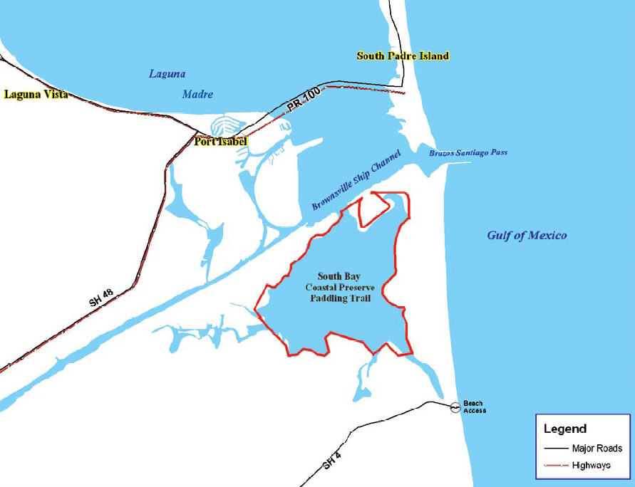
Boca Chica Beach is located just east of Brownsville, Boca Chica is a sandy peninsula separated from Mexico by the Rio Grande River and detached from South Padre Island by the Brazos Santiago Pass. Aside from a few stilt homes near the pass, which can be viewed from South Padre Island, and a jetty protruding into the Gulf of Mexico, Boca Chica Beach has no development whatsoever. The State of Texas does own land on Boca Chica which, technically speaking, is a state park. However, there are no park facilities on this land.
Although Boca Chica has little in the way of modern amenities, it does offer a variety of outdoor recreational activities, including fishing, swimming, surfing, snorkeling, kiteboarding and birdwatching. It is also the ideal place to get away from everything.
Getting to Boca Chica is a snap. From Brownsville, take Highway 4 east until it runs out. Once you hit the beach, you can either go right to the mouth of the Rio Grande or hang a left and cruise up to the north end, which is directly across from South Padre Island.
|
| |
| MAPS / Photos of Interest: |
| |
South Bay Paddling Trail
This map is also available in a durable laminated version from select retailers. To get a list of these retailers contact Shoreline Publishing at 713-973-1627.
Road Map to South Bay Paddling Trail
|
| |
| What to Pack/Bring: |
| |
See Standard PACK List for items to consider for any PACK outing
Important items:
- VHF Radio for communication and emergency contact
- First Aid Kit
- Lunch, Water, snacks
- Kayak Drift Sock
|
| |
| REQUIRED READING: |
| |
Recommended guidelines for participates:
- Make sure trip leader or an officer has your emergency contact
- Notify the trip leader if you have any potential concerns
- If inexperienced, then buddy up. Make sure the trip leader knows your experience level
- Communicate with the trip leader, if you are unsure of your skill level required
- Member dues are current
- Guests are invited to particpate
- Have performed deep water entries
- Cary a first aid kit
- Have a life jacket
- Have a VHF radio
- Inform the trip leader of your float plan if planning to fish alone or longer then the designated times.
- Sign in and sign out at the launch site. Inform the trip leader if you will be launching in a different place.
Recommended for Trip Leaders:
- Insures proper authorizations
- Secure sites
- Prepare emergency preparedness plan
- Keep abreast of weather conditions that might effect the trip
- Point out any potential area hazards
- Maintain a head count
- Have available a first aid kit
- Have a VHF radio
|
| |
|
Expenses/Fees:
|
| |
Where do we camp? We have the option to primitive camp on Boca Chica Beach, there is the issue of safety, unattended vehicles.Options could be to camp at Isla Blanca Park or White Sands Motel and make the drive over to Boca Chica State Park. In any case our vehicles will be vunerable while we paddle.
|
| |
| Guest Participants: |
| |
(We prefer for you to create a login account on this website so that you can have your name added to the auto register list below. If you don't have a registered login account on this website we can list your name here; please contact the trip leader to request your name to manually added. If you have a login account then use the enroll feature at the top of this page to become part of the auto enroll list below)
-
-
|
| |
|